Community Corner
It’s May 3 ... And It’s Snowing Again
Northfield is expected to receive snow through 1 p.m. Friday. Will it be the final time we see snowflakes until this fall?
Today is May 3. So, of course, it’s snowing again.
At about 10 a.m. Friday, clumpy snowflakes were falling in downtown Northfield.
But unlike Wednesday night and Thursday morning—when, according to the National Weather Service, Northfield received 6.8 inches of snow—the white stuff wasn’t sticking to streets and sidewalks in the city’s downtown business district.
Find out what's happening in Northfieldwith free, real-time updates from Patch.
The weather service has issued a hazardous weather outlook for Northfield and Rice County. Here is the text of that outlook:
.DAY ONE...TODAY AND TONIGHT
THROUGH THE MORNING...ANOTHER ROUND OF PRECIPITATION WILL SPREAD NORTH OUT OF SOUTHEAST MINNESOTA. THIS WILL START OUT AS SNOW...BUT WILL START MIXING WITH FREEZING RAIN DURING THE MORNING BEFORE TRANSITIONING TO ALL RAIN BY THE AFTERNOON.
Find out what's happening in Northfieldwith free, real-time updates from Patch.
DAYS TWO THROUGH SEVEN...SATURDAY THROUGH THURSDAY
RECENT WET CONDITIONS OVER THE LAST SEVERAL WEEKS IN WESTERN WISCONSIN...COMBINED WITH RAPID MELTING OF SNOW THIS WEEKEND WILL RESULT IN THE POTENTIAL FOR AREAL AND SOME RIVER FLOODING IN WESTERN WISCONSIN INTO NEXT WEEK.
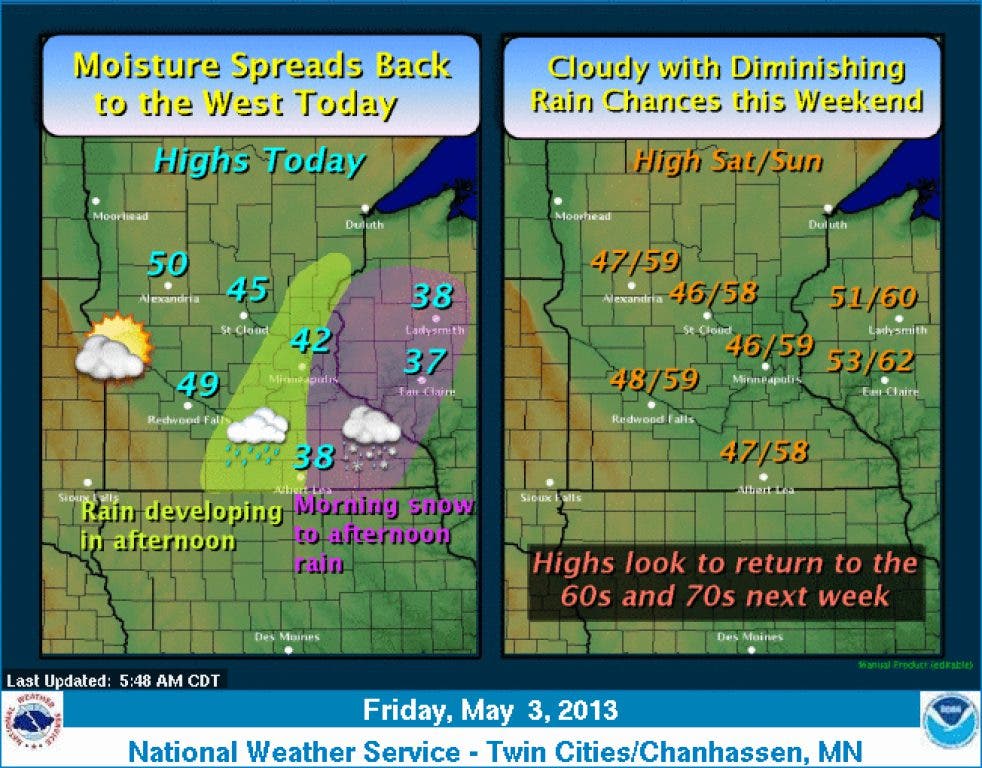
Here is the weather service’s weekend forecast:
TODAY: Snow before 1pm, then rain and snow between 1pm and 3pm, then rain after 3pm. High near 39. North northeast wind around 15 mph. Chance of precipitation is 90%. Total daytime snow accumulation of less than one inch possible.
TONIGHT: Rain and sleet, becoming all rain after 9pm. Low around 35. North northeast wind 10 to 15 mph. Chance of precipitation is 90%. Little or no snow accumulation expected.
SATURDAY: Rain likely. Cloudy, with a high near 45. North wind around 10 mph. Chance of precipitation is 60%. New precipitation amounts of less than a tenth of an inch possible.
SATURDAY NIGHT: A 40 percent chance of showers. Cloudy, with a low around 40. North wind 5 to 10 mph.
SUNDAY: A 20 percent chance of showers. Cloudy, with a high near 58. North wind around 5 mph.
SUNDAY NIGHT: Mostly cloudy, with a low around 43. North wind around 5 mph becoming calm in the evening.
A TRULY HISTORIC SNOWFALL
If you are looking for a prespective on how historic the May 1-2 snowstorm what, KSTP meteorologist Ken Barlow may provide it.
Barlow wrote these two tweets on Thursday night:
[Rochester] picked up 13.9” of snow today. All up ALL May snowfalls on record and they equal 4.3”
From 4 pm: New state record set for MN May snowfall! 18” at Blooming Prairie (just N of Austin) beats 12” near Leonard (N of Bemidji) 5/3/54
Here is a list of posts on Northfield Patch about the snowstorm. Click on the headline to read the post:
• Northfield Gets Back to Normal After Snowstorm Disrupts Morning Routines
• UPDATE: Electrical Outages Continue in Northfield
• • UPDATE: Northfield Schools Closed on Thursday
• UPDATED: National Weather Service Calling for 3-7 Inches of Snow Tonight
• Weather Channel Meteorologist Reports Live from Downtown Northfield
